

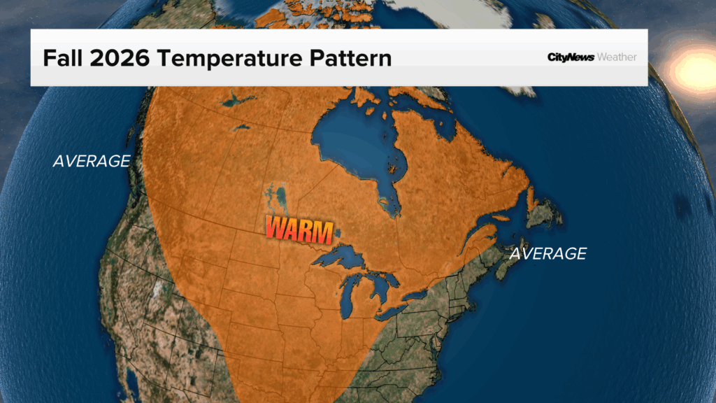
Fall arrives on Tuesday and it’s looking to be warmer and drier than average this year for most of Canada.
Parts of Atlantic Canada, the lower Great Lakes and coastal British Columbia will be closer to average in terms of temperatures. But most of Canada is expected to be warmer than average, with Northern Canada likely seeing the greatest temperature anomaly, or departure from normal.
In terms of precipitation, Southern Ontario will be grazed by some moisture but most of the wet weather this season will remain stateside.
CityNews Chief Meteorologist Natasha Ramsahai says a “good chunk” of the country is expected to be drier than average or average in terms of snow and rain.
“This is going to be a big problem as we go into the next few months. If we’re going to be dry now… early indications are that a good chunk of Canada will also stay dry through the winter as well and that’s going to have some implications when it comes to spring and summer,” she said.
“If there’s not a lot of snow melt, if there’s no snow for insulation and we’ve got very dry soil and dry ground we’ll be possibly talking about these implications for wildfire season next year.”
Southern Ontario fall outlook
Like the rest of the country, southern Ontario will be warmer and drier than average this season, except around Lake Erie and southwestern Ontario that could get grazed with a little more moisture.
The region will feel the effects of the super El Niño and fall, going into winter, will see less cold air coming over the Great Lakes.
Ramsahai says this could have wide ranging impacts on ice wine and maple syrup production. Fewer snow squalls could also have an impact on recreational winter sports, especially the ski hills north of Toronto. Freeze-thaw cycles are also likely to be more prevalent, which could mean more potholes in the city, and less ice on the Great Lakes could extend the shipping season.
“But less ice on the Great Lakes as a whole is bad news for recreational activities and for the lakes themselves. We need that ice on there for fish ecosystems to thrive underneath the ice in the winter,” said Ramsahai.
There is also an increased risk of freezing rain in southern Ontario and heavy rain falling on frozen ground could increase the potential for flooding.
Key drivers of warmer fall weather
Ramsahai explains that there are dozens of “teleconnections” that can affect how the season will play out. Put simply, teleconnections are meteorological occurrences in one part of the world, the impacts of which are felt in another part.
El Niño Southern Oscillation (ENSO)
The most familiar teleconnection is the El Niño climate pattern which develops as a result of above-average sea surface temperatures in a defined area of the Pacific Ocean known as the Niño 3.4 region.
As of two days ago, the Niño 3.4 region is 3.05 C above average, which means it has surpassed “super El Niño status.”
“And it hasn’t even reached its peak yet, its going to continue to strengthen through November and December,” said Ramsahai.
North Atlantic Oscillation (NAO)
The North Atlantic Oscillation is a weather pattern that is created by changes in atmospheric sea-level pressure between theAzores High and the Icelandic Low over the North Atlantic Ocean.
Ramsahai says the NAO is currently in a neutral phase.
This means the typical “blocking pattern” that’s expected with the Jetstream over Greenland which keeps the cold air injections coming over southern Ontario and keeps the warmth to western Canada might not occur and that warmth can spread all across the country.
Pacific Decadal Oscillation (PDO)
The Pacific Decadal Oscillation is a climate pattern defined by changes in sea surface temperatures and atmospheric pressure across the North Pacific Ocean.
Ramsahai says this helps to mute some of the warming effects of El Niño, however because El Niño is in record breaking territory, it is yet to be seen how much the PDO will help temper it.
Will we have a white Christmas?
It is way too early to say for certain as local weather effects have yet to be determined, but Ramsahai says that because of climate change as a whole, the chances of a white Christmas have reduced considerably over the past several decades.
Comparing the 24 year period from 1960-1984 to the period from 1997-2023, the chance of a white Christmas for most Canadian cities has gone down.
For example, Toronto is 30 per cent less likely and Montreal is 16 per cent less likely to have a white Christmas.

Seasonal forecast caveats
Ramsahai cautions that a seasonal outlook is not meant to be used for day-to-day forecasts, but rather provides clues on what may be more or less likely in a given season.
Every year is unique and contains an inherent degree of uncertainty since many atmospheric factors are not predictable weeks or months in advance.
Lastly, she says that this year’s super El Niño is unprecedented and since it is new territory, “we could be in for some surprises.”


Add CityNews Toronto as a trusted source on Google to see more local stories from us.