

In this epic jaunt through national capital history, writer Randy Boswell rescues characters and details that have been lost to time, adding a new chapter to the capital’s origin story.
There is no uncertainty about the place where today’s Ottawa was born. Thousands of tonnes of quarried stone — the eight-stage headlocks of the Rideau Canal — mark, precisely, where the canal and old Bytown, the future city of Ottawa, got their start.
But there are parts of the seminal “moment” in Ottawa history — the reason the city is marking its 200th anniversary in 2026 — that have never been told. Ottawa’s birth has typically been summed up by local historians as an auspicious meeting of two dauntless British men: Lt.-Col. John By, the English military engineer assigned to build the Rideau Canal and found a settlement, and Lord Dalhousie, the Scottish-born Governor-in-Chief of British North America, who together, on Sept. 26, 1826 at a backwoods outpost, decided the location of the future capital of Canada.

That is true. But a closer, lingering look at the genesis story of Bytown-Ottawa invites a more considered and layered understanding of how this moment came to be, and notably, who else was present but previously ignored in the retelling.

The Evening Citizen
One of the best guides for understanding that watershed week in Ottawa history is the private journal of Lord Dalhousie himself — George Ramsay, the 9th Earl of Dalhousie and colonial Canada’s de facto ruler from 1820 to 1828. Archival documents and old newspapers, many now digitized and easy to peruse, add fresh detail to the well-worn narratives found in local history books. And amazingly, there are places to go and things to see in 2026 that still tangibly connect us to the story of Ottawa’s origins two centuries ago.
The events of Ottawa’s birth played out, not in a single day, but over more than a week in late September 1826.
•••
The idea of building what is now a 202-kilometre-long, UNESCO World Heritage-designated waterway that connects Lake Ontario by squiggly liquid line, via the Cataraqui and Rideau river systems, to the Ottawa River. made a lot of sense in the years following the War of 1812.
With American forces in a position to menace British forts, settlements and ships along the Lake Ontario-St. Lawrence River frontier, a secure, inland water route that could aid the movement of troops and military supplies between Kingston and Montreal, and the creation of a new town far from the U.S. border, would offer some peace of mind in Upper and Lower Canada should the December 1814 peace deal that ended the conflict ever unravel.
After years of planning and surveying, the canal project began in earnest with the simultaneous selection of the locale for the Ottawa River headlocks and the decision to build a two-sided village on lands to the east and west of the waterway’s entrance — what became Ottawa’s Lower Town and Upper Town respectively, including Parliament Hill.
And the formal approval for each was clearly laid out in a letter that Lord Dalhousie — who had purchased the lands in 1823 for government purposes — wrote and delivered by hand to Col. By on Sept. 26, 1826.
The letter, often described as the “birth certificate” of Canada’s capital, was penned after the two agents of imperial Britain had, together, visually inspected the Ottawa River’s southern shoreline. They settled on a gully with trickling water, set between picturesque limestone bluffs, as the best spot to start the canal.
“I take this opportunity of meeting you here,” Dalhousie wrote in his letter to By, “to place in your hands a Sketch Plan of several Lots of Land, which I thought advantageous to purchase for the use of Government, when this Canal was spoken of, as likely to be carried into effect. This not only contains the site for the Head Locks, but they offer a valuable locality for a considerable Village or Town . . .”
•••
A few weeks earlier, the Governor-in-Chief and Lady Dalhousie — Christian Ramsay, a Scottish aristocrat keenly interested in science and the arts — had travelled up the St. Lawrence River from Quebec City, the capital of Lower Canada, and reached Montreal on Sept. 14, 1826. Over the next few days while staying at the New Masonic Hotel, they twice attended plays next door at the Theatre Royal, where, according to the Montreal Gazette, “they seemed highly delighted with the performance of Miss Kelly” — the English actress and singer Lydia Kelly, renowned for her portrayal of Beatrice in William Shakespeare’s greatest romcom, Much Ado About Nothing. Then the vice-regal couple prepared for a three-day river voyage to the northwest that, in terms of Ottawa history, could be described as Much Ado About Everything.
The Earl’s meeting with Colonel By would result in not only the final selection of the canal entrance and confirmation of plans for a town site, but also the approval of a series of bridges to connect Upper and Lower Canada across the Ottawa at the Chaudière Falls and — at the request of the region’s fledgling logging industry — a dredged channel at Richmond Landing, on the south shore, to ease the passage of valuable timber rafts around the turbulent Chaudière.
At 6 a.m. on Sept. 21, 1826, the vice-regal couple and an entourage of colonial officials left Montreal. In two large stage coaches, they were whisked to the western tip of the Island of Montreal near the confluence of the St. Lawrence and Ottawa rivers — today’s Ste-Anne-de-Bellevue, but known to Lord and Lady Dalhousie as “St. Ann.”
From about 9 to 10 a.m., they had breakfast. And it was during this stop that Lady Dalhousie, an avid gardener and important collector of botanical specimens from Quebec and the Maritimes, appears to have snapped a sprig of four leaves from a maple tree to press into one of her many albums of Canadian plant samples. With elegant, cursive handwriting, she indicated the location of the specimen-taking as “St. Ann” and dated it (inaccurately, as it happens) “Sept. 24th 1826.” That’s the day, 72 hours later, when the travellers would arrive for their three-night stay at the fine manor of the capital region’s first settler, Philemon Wright; perhaps that was the first opportunity after their 180-kilometre river trip from Montreal that Lady Dalhousie could spare a moment to label and date the sprig she’d collected along the way.
The Countess of Dalhousie was no mere hobbyist. She was a major contributor to a landmark scientific publication of the era — British botanist Sir William Jackson Hooker’s Flora Boreali-Americana, or the Botany of the Northern Parts of British America. The epic 1829 volume was Europe’s most comprehensive introduction to Canadian plant life and contained scores of entries attributed to Lady Dalhousie and a network of fellow female collectors in Quebec she had introduced to Hooker.
The botanical work of dedicated amateurs such as Lady Dalhousie and her nature-loving peers was part of an enthusiastic embrace of “inventory sciences” in colonial Canada — a stock-taking of plants and animals, rocks and minerals, water power and all other natural resources — to facilitate settlement, agricultural development and economic progress. It was also, however, part of a process of appropriating the land, resources and knowledge of Indigenous people who had inhabited Canada for thousands of years.
Contact-era relations between Indigenous people and Euro-Canadian newcomers were complex and sometimes contradictory. There was much conflict, but also cooperation, as the juggernaut of colonization rolled across British North America. Later on the journey up the Ottawa, while pausing for lunch near present-day Montebello on Sept. 23, Lord Dalhousie would encounter a settler named Pierre Lacasse, whose adult son had suffered a crippling leg injury while labouring on the land and had been “bedrid for 3 months,” according to the Governor’s journal.
“Surgeons did him no good,” Dalhousie wrote, “but an old Indian woman saw him, brought some herbs with her some days afterwards, and completely restored him. This is one of many instances I have met with which point out the wisdom in Government establishing a Botanical garden, to search out from native Indians the medicinal herbs and dye plants of this new world.”
Lady Dalhousie’s maple sprig wound up in the ancestral castle of her Scottish family after she and Lord Dalhousie returned to Britain in 1828. Along with other artifacts, maps, documents and sundry souvenirs from their time in Canada, it remained forgotten in storage for well over a century until it was discovered in the 1980s — along with the rest of the treasure of Canadiana — by Nova Scotia historian and curator Marie Elwood. In the early 1990s, Ontario’s Royal Botanical Gardens acquired Lady Dalhousie’s lost-and-found herbarium of Canadian plants, including the maple sprig that seems to have accompanied her upriver for the founding of Bytown.
With sleuthing assistance from Ottawa naturalist Daniel Brunton, who has researched and written about Lady Dalhousie’s later botanical collecting in the Ottawa region, photos of the 1826 maple sprig were obtained from an RBG curator. The specimen — which Brunton suspects may have come from a hybrid black and sugar maple — is “surprisingly intact — in excellent condition given that it’s 200 years old,” he said, adding it was “carefully curated” by a highly skilled collector.
In the context of Bytown’s bicentennial, we can think of this amazingly well-preserved, time-capsule twig — a maple, of all things, from the dawning days of Canada’s capital — as a kind of surviving witness to the founding of future Ottawa.
•••
The vice-regal party continued their journey “in our two canoes, or rather, bateaux,” Dalhousie noted in his journal, having eschewed the newly available option of steamship travel up a good stretch of the Ottawa. A Gazette report described the vessel carrying Lord and Lady Dalhousie as “a very fine barge of 15 oars, called the LACHINE, prepared for the occasion and manned by experienced voyageurs dressed in proper costume. The barge, among other flags, bore one with the coat of arms of His Excellency.”
Their next stop a few hours later was the “Indian village on the Lake of the Two Mountains,” as Dalhousie referred to the Catholic mission, established in 1721, where about 400 Indigenous converts to Christianity were living in 1826 around a central church under the authority of Monsignor François-Joseph-Michel Humbert.
It is worth pausing here, at a place we know today as the Quebec town of Oka and the Kanesatake Mohawk First Nation, to ponder the dark legacies of Canadian history, but also the modern resistance and resilience of Indigenous peoples — particularly in the wake of the watershed “Oka Crisis” of 1990 — after centuries of oppressive treatment by both French and British colonial powers, generations of Christian missionaries, and ultimately the post-Confederation government of Canada.
That was the backdrop to a controversy over disputed lands and the ensuing violent standoff between Mohawk Warriors and Quebec police — backed by the Canadian military — that drew international attention to Oka throughout the summer of 1990.
The Lake of Two Mountains mission in 1826 saw Iroquoian Mohawk, as well as Anishinabe Algonquin and Nipissing peoples, encamped in different areas of the village, though many returned seasonally to their nation’s traditional hunting grounds. Humbert ominously told Dalhousie of “some measures of severity he had been obliged to take” to prevent the intermarriage of local French-Canadian women and Indigenous men, and denigrated all for their “loose bad character” and “jealous” behaviour.
“Each nation hunts on distinct & separate tracts,” Dalhousie wrote after his briefing from Humbert. “They cannot agree, and cheat each other in every way imaginable.” The Gazette, in its report on the Governor’s visit to Lake of Two Mountains, dismissively described a ceremony in which “some of the orators made harangues in the Indian fashion.”
With Canada then on the cusp of its most intense period of colonization, First Nations were facing relentless disruption and dislocation, cultural and spiritual repression, and the kind of blind disdain that Dalhousie, Humbert and the Gazette writer so readily expressed on the eve of Bytown’s birth.
On Dec. 6, 1826, within weeks of Dalhousie’s visit to Lake of Two Mountains, leaders of the Algonquin and Nipissing people living at the mission would file a petition to the Governor — echoing many previous appeals — that called for stronger protection of their traditional hunting grounds throughout the Ottawa River watershed and compensation for lands already lost or earmarked for imminent settlement.
“About one third of Your Petitioner’s hunting lands had been taken within a few years by Government and laid out in Townships for the settlement of the Whites and no compensation whatever has been made to your Petitioners for the same,” the leaders pleaded through their translator, adding that “they foresee that the remainder of their lands will soon be taken away from them for the same purpose, without compensation . . . (In) such case they will become quite destitute and deprived of all means of supporting their families, having no other property that they can call their own.”
It is no coincidence that the intensifying exasperation and even desperation of the Indigenous petitioners about the future of their lands and communities was expressed so soon after the founding of Bytown.
One signatory of numerous such petitions during this era was the Anishinabe leader Chief Louis Pierre Constant Pineso (also spelled Penency, Penaise and other variations), who had fought with his four sons as a British ally during the War of 1812. Chief Pinesi may well have been present during Lord Dalhousie’s afternoon stop at Lake of Two Mountains on Sept. 21, 1826. In fact, he may have even delivered one of the “harangues” mocked by the Gazette, but which should be understood today as one of countless appeals for justice for the Algonquin people that would fall on deaf ears.
As a direct ancestor of many of today’s residents of Pikwakanagan First Nation west of Ottawa — including 21st-century chiefs Kirby Whiteduck, Wendy Jocko and Greg Sarazin, as well as veteran band councillor Merv Sarazin — the story of Chief Pinesi’s struggle to maintain some control over the traditional territory of his people during the settling of the Ottawa Valley has been revived and retold in recent years with great pride among contemporary Algonquin communities.
•••
•••
Two centuries after the founding of Bytown, former chiefs Whiteduck and Jocko led a July 2026 gathering of about 50 people on the Ottawa River shore behind the Canadian Museum of History to launch an annual canoe trip honouring Chief Pinesi. This year, the paddlers — Algonquins and non-Indigenous participants together — made a stop at the Lake of Two Mountains cemetery site where Pinesi was buried after his death from cholera in 1834.
Whiteduck reminded listeners that in the 1820s and for decades afterwards, Pinesi and other petitioners pleaded with Dalhousie and his successors to honour their promises to the Algonquin people that expansive stretches of their traditional Ottawa Valley hunting grounds, as well as their resource rights and cultural autonomy, would be protected. “Instead, they were pushed back and pushed around in their own territory, and they were starving,” said Whiteduck, describing the devastating impact of “colonization and occupation” on Algonquin peoples after centuries of “living well” in the pre-settlement era.
“There’s two stories obviously,” said Jocko, commenting on Ottawa’s bicentennial. “There’s the colonial history, but there’s the Algonquin and other Indigenous peoples of the area — their history. I think it has to be told as one.”
Present-day Ottawa residents, said Jocko, “should certainly know the plight of the Indigenous people at the time, and how Chief Pinesi and respective chiefs really spoke up for their people. But the colonial government basically erased them — erased them so far that many Algonquin people today do not even know about Grand Chief Pinesi.”
Another revered Anishinabe leader of the 19th century, Luc-Antoine Pakinawatik, may also have been present at Lake of Two Mountains when Dalhousie visited in September 1826. He had been married there the summer before, as recounted by Algonquin historian Stephen McGregor in Since Time Immemorial: The Story of the Kitigan Zibi Anishshinàbeg. Pakinawatik would eventually lead the fight that resulted in the founding of the River Desert Reserve in the early 1850s — today’s Kitigan Zibi Anishshinàbeg community near Maniwaki, Que., about 100 kilometres north of Ottawa-Gatineau.
The late Kitigan Zibi chief William Commanda, renowed peace activist, environmental advocate and namesake of an Ottawa-Gatineau bridge over the Ottawa River, was Pakinawatik’s great-grandson. And William’s granddaughter, Indigenous rights activist and Algonquin elder Claudette Commanda, is a professor and chancellor at the University of Ottawa and CEO of the First Nations Confederacy of Cultural Education Centres, who has led a fight for justice for Federal Indian Day School Survivors.
Albert Dumont, an Algonquin poet and spiritual guide from Kitigan Zibi, served as Ottawa’s poet laureate from 2001 to 2023. He recently published a collection titled The Sound My Heart Makes, including one poem titled “The City of Ottawa”:
When your city was being planned
The Anishinabe Algonquin drum
Was not heard
Our songs, not requested
Our voice
Not asked to contribute
Our ancestors
Were not summoned
But still you went ahead
And your city came to be
Where we once feasted and played
Where the bones of our dead lay
Your city came to be
•••
Initial encounters between the Anishinabe Algonquin and Philemon Wright, the American-born lumber baron, foreshadowed the fallout to come for the Indigenous people whose ancestors had lived in the Ottawa Valley for millennia. In the early 1820s, two decades after founding his Hull settlement, the man who had become a wealthy farmer, landowner and timber baron gave testimony to the Lower Canada legislature recalling his early interactions with Indigenous inhabitants in their hunting grounds — the lands Wright had emigrated from the U.S. to take possession of under colonial law.
In February 1800, Wright, 25 hired men and five families met an Algonquin man who — “without the promise of fee or reward” — guided them 100 kilometres up the frozen Ottawa River out of concern that Wright’s party of settlers would fall through the ice.
Soon after Wright established the group’s first settlement site near today’s Lac Leamy in the future Gatineau — clearing trees for their homes and barns, including sugar maples used by the Anishinabe people to produce syrup — “the chiefs of two tribes of Indians” from the mission at Lake of Two Mountains asked Wright through a translator “by what authority I was cutting down their wood and taking possession of their land.”
Wright explained it was ultimately King George III who authorized his settlement project, the location of which would be key to the establishment of Bytown a quarter-century later. In his testimony to legislators, Wright recalled the astonished reaction of the two chiefs that the “Great Father” in Britain — the King — “would allow me to cut down their Timber and clear their Land and destroy their sugaries and hunting ground without consulting them, as they had been in the peaceable and quiet possession of these lands for generations past.”
After Dalhousie’s visit to Lake of Two Mountains in September 1826 and many more petitions from Indigenous leaders, it would be decades before the Anishinabe families living at the Oka mission and elsewhere throughout the Ottawa Valley would finally secure reserve lands in Eastern Ontario and West Quebec — including today’s Pikwakanagan and Kitigan Zibi communities, both entwined in the present-day political, economic and cultural fabric of the national capital area.
But both of those reserve lands represent a tiny fraction of the territories in Ontario and Quebec once commanded by Algonquin peoples, and which was never ceded to the colonizers who came in relentless waves after 1800, and especially after 1826. In his history of Ottawa Valley Anishinabe people, McGregor recounts how Wright’s lumber empire and By’s canal project both hinged on the acquisition and exploitation of Indigenous lands and resources. “Governor Dalhousie was well aware of this,” McGregor writes, adding that the steady stream of petitions from Algonquin leaders was therefore “of no consequence to him . . . The British had the economic boom they needed from which to build a country. It was Algonquin land that provided them that opportunity.”
Algonquin Anishinabe scholar Lynn Gehl, author of 2017’s Claiming Anishinaabe, has recounted the impact of several questionable land “purchases” and other colonial policies in the late 1700s and early 1800s: “European settlements in the Ottawa Valley began to grow and invade at an exponential rate,” she writes. “With the influx of European settlers, Algonquin people were ‘mapped out’ of their landscape’s bounty.”
In this era of truth and reconciliation, the Indigenous people — whose bonds with the land that became Ottawa reach back thousands of years — are held in high esteem by municipal, provincial and federal leaders. But through ongoing land claims on both sides of the Ottawa River — for centuries the “Kichi Zibi” lifeblood of Algonquin commerce and culture in the capital region — they are still seeking restitution, 200 years after the founding of Bytown, for lost but never ceded territory throughout their ancestral watershed.
•••
The vice-regal party left the Lake of Two Mountains mission and its Indigenous encampments in the mid-afternoon of Sept. 21, reaching the town of St. Andrew’s at about 6 p.m., where they overnighted. Dalhousie noted in his journal that the town and its surrounding area on the river’s north shore were part of “the seigneurie of Argenteuil, belonging to Sir John Johnson” — a reference also weighted with meaning about the relationship between British North American officialdom and the First Nations people of Upper and Lower Canada.
Johnson was 84 in September 1826 but still serving as Superintendent-General of Indian Affairs, a post he’d held for over four decades — and which his famous father, William, had held for 20 years before the American Revolution. Both Johnsons were widely respected by First Nations leaders for their efforts — however futile in many instances — to protect Indigenous communities from the impacts of colonization. Sir John Johnson in particular advocated for the Algonquin and Nipissing nations to secure compensation for losses of land and resources in the settlement era, and to reward their loyalty to the British crown during military conflicts with Americans during the U.S. War of Independence and War of 1812.
But Johnson clashed sharply with Dalhousie, who by the 1820s was prioritizing the needs of settlers and military planners over the rights of Indigenous nations, which he viewed as obstacles to the progress of the British Empire. In one journal entry, Dalhousie had judged Johnson with sneering suspicion as a man who exhibited “a kind of wildness, as if he wished to appear a character tinctured with the habits and the intercourse he has had with the Indian tribes.” Johnson biographer Earle Thomas observed that the carefully nurtured trust Johnson had established with Mohawk, Algonquin, Nipissing and other Indigenous leaders was undermined “during the regime of the opinionated, resolute and unbending Dalhousie.”
When Johnson died in 1830, some 300 Indigenous people from Lake of Two Mountains and other First Nations villages attended the funeral in Montreal. Historian Noreen Kruzich, whose 2011 book The Ancestors Are Arranging Things chronicles the life and struggles of Chief Pinesi and his Algonquin descendants, said Johnson’s death, “no doubt, represented a great loss for the awareness of the many promises made to the tribes.”
Kruzich, whose book has been touted by Pikwakanagan leaders as recommended reading for understanding the Algonquin perspective on Ottawa Valley history, contrasted Johnson’s enduring “empathy for the fragile situation” of the Algonquin people and Dalhousie’s zealous promotion of colonization and his indifference toward its impacts on First Nations — specifically the “settlement by the headlocks of the planned canal system set at the junction of the Rideau and Ottawa rivers.”
•••
Lord and Lady Dalhousie and the other travellers from Montreal spent the night of Sept. 22 just 25 kilometres upriver from St. Andrew’s at Grenville, where a military camp had been established for the ongoing construction of the Grenville Canal through a long stretch of Ottawa River rapids. Dalhousie and the engineers in his entourage spent a day inspecting the canal works. Then the vice-regal party was rowed the next leg of the journey to the village of L’Orignal on the Upper Canada side of the river, where former Montrealer Jacob Marston hosted the distinguished visitors in his newly built stone house — today the oldest heritage building in the Eastern Ontario town. Dalhousie wasn’t impressed with Marston’s “very poor and unfurnished” home, but “a very merry time” was had anyway, with singing and socializing on a Saturday night in the wilds of what would become the United Counties of Prescott and Russell, about 55 kilometres east of present-day Ottawa.
It was 3 p.m. on Sunday, Sept. 24 when Lord and Lady Dalhousie arrived at the north shore boat landing below the Chaudière Falls — directly across the river from today’s Parliament Hill — and took a carriage ride the short distance to their comfortable lodgings at the home of Philemon and Abigail Wright. The Wrights had long since moved west from their original homestead on Lac Leamy (then called “Columbia Pond”) to establish a farm on lands that would be near the urban core of Hull-Gatineau.
Colonel By and his first assistant — fellow Royal Engineer Lt. Henry Pooley — “were ready to receive us, and my old friend Philemon had his house all ready for us,” Dalhousie’s journal records. He had previously been Wright’s guest during an 1820 inspection tour of the Upper Ottawa and Rideau River frontiers. Lady Dalhousie’s journal noted that Dr. Alexander Christie — a former Montreal journalist and self-trained physician who would become an important figure in early Bytown — was also there to greet the vice-regal entourage.
As fond of the Wrights as Dalhousie appeared to be, the couple clearly struck Canada’s Governor-in-Chief as odd, unpolished transplants from America out of sync with British customs and manners: “It is impossible to think without laughing,” Dalhousie later wrote in his journal, “at the absurdities of our stay under Philemon’s roof, the vulgarity of himself and (his) wife, the strange Yankee language and phrases and tone.”
By and Pooley, as well as stonemason Thomas Mackay — a proven master of his craft after completing construction of Montreal’s Lachine Canal a year earlier — had come up the Ottawa a few days ahead of the Governor’s party, arriving at Wright’s Town on Sept. 21.
A week before that, By had written to his boss, Col. Elias Walker Durnford — commander of the Royal Engineers in Canada, and a member of Lord Dalhousie’s travel party — to lay out his plan to “proceed to Hull immediately and examine the Ottawa . . . to ascertain the best situation for the entrance of the proposed canal, the judicious choice of which is an object of the first importance . . .”
In an earlier report to his superiors, By had referenced the origins of the canal project as a vital defence measure following the War of 1812 between Britain and the United States, expressing his confidence that the inland waterway he was about to build to connect Kingston and Montreal via the Cataraqui, Rideau, Ottawa and St. Lawrence rivers would achieve the goal of “rendering Canada perfectly secure and safe from any attack the Americans may hereafter meditate.”
Joined at Wright’s Town by a team of surveryors and labourers ready to commence work on the canal as soon as the planned entrance was approved by Dalhousie, By had ordered the clearing of trees and the establishment of a camp on the Upper Canada side of the river across from Wright’s Town.
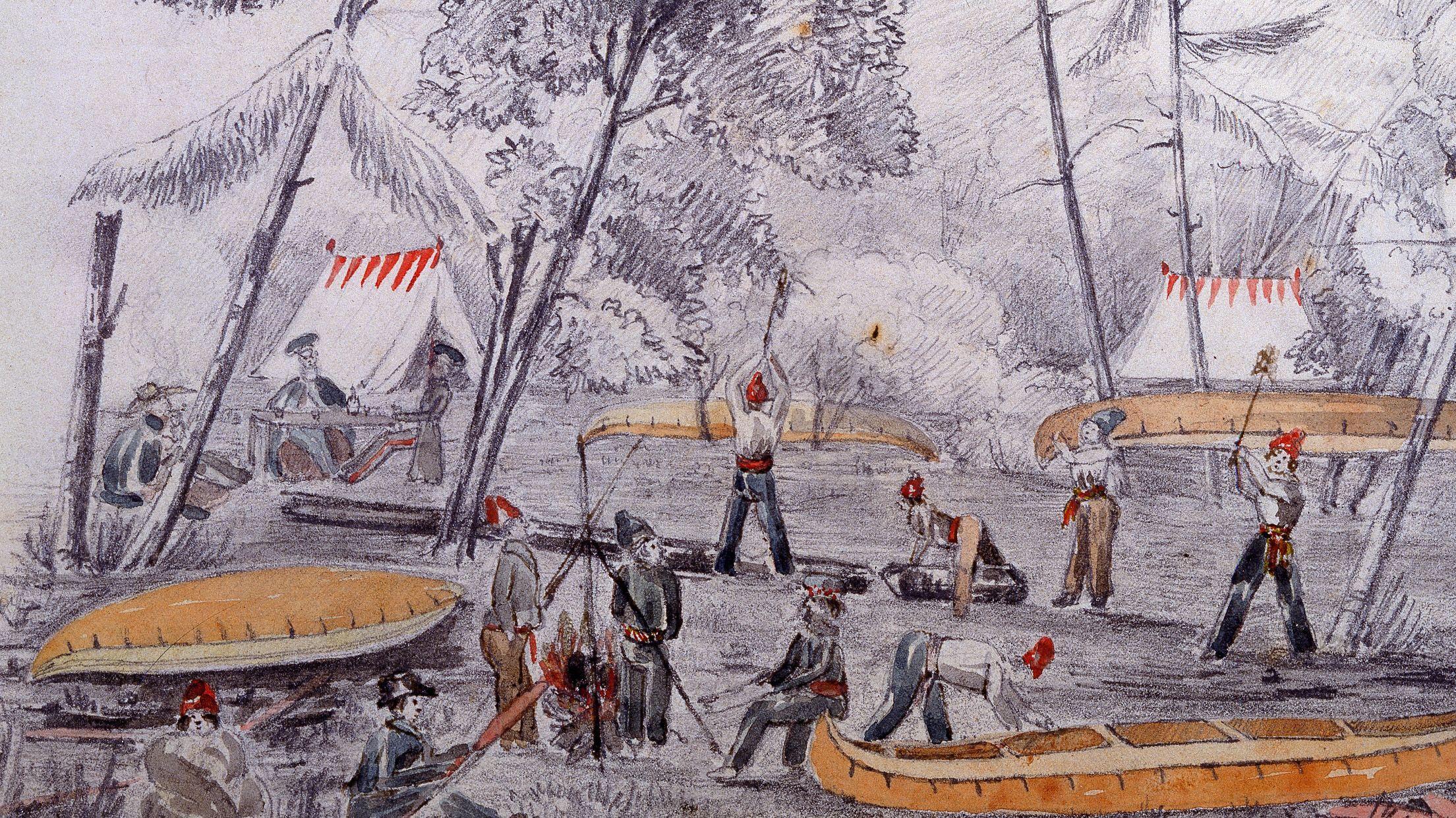
This “First Camp” is captured, astonishingly, in a pencil and watercolour sketch dated 1826 and attributed to By himself. Held by the McCord Stewart Museum in Montreal, the image (slightly larger than a postcard) shows 15 men — a few chopping logs, others carrying or clearing out canoes, two tending a fire, one having a snooze on the ground — with two tents and a thick forest in the background. Ottawa author Alastair Sweeny, who published a superb biography of Mackay in 2022, speculates that By has depicted himself and Mackay at the left edge of the sketch having a drink at a camp table as they discuss the canal project. A third figure seated near the other two is thought by some historians to be a depiction of Philemon Wright.
•••
Before Dalhousie’s arrival on the 24th, a reconnaissance trip with Pooley and Mackay along the south bank of the river had already convinced By — who’d never before been to the place that would soon bear his name — that Sleigh Bay offered the best location for the canal’s headlocks. (Sleigh Bay was named for the 1819 winter wedding of one of Philemon Wright’s sons and his bride, which took place on the frozen south side of the Ottawa within a horse-and-cutter ring of guests attending the ceremony. The marriage officiant, as we might call him today, was not licensed to perform the nuptials on the Lower Canada side of the river.)
The choice had the benefit of bypassing a route that would have put the Ottawa entrance of the canal on disputed lands owned by Captain John LeBreton, a military officer angrily accused by Lord Dalhousie of using insider information — shared years earlier by Dalhousie himself — to speculatively purchase an acreage around Richmond Landing, about one kilometre west of Sleigh Bay, on the belief that the headlocks would be built there, on today’s LeBreton Flats.
That’s why, on the morning of Sept. 25, Lord Dalhousie and Colonel By — accompanied, no doubt, by Durnford, Pooley and other members of their respective entourages — gathered on the shore of Sleigh Bay to confirm the entrance site and to embark on an extraordinary tramp. They walked for hours and hours, through alternately swampy and forested terrain, along the route where the canal would soon be carved across what is now the urban core of a city of 1.2 million people.
“Yesterday, we had a most pleasant and interesting walk thro’ the woods,” Dalhousie wrote in his journal on Sept. 26. They set out “from the basin on Ottawa where the Canal is to enter, to that point where it will meet the river Rideau about six miles inland. In some spots the line is swampy & level, in others magnificent timber trees, which I could not help almost to covet, wishing a house amongst them. They are chiefly Pine & Basswood . . .”
If Dalhousie, By and company had done no more than hike from Sleigh Bay to the opening of the Rideau above Hog’s Back Falls at today’s Mooney’s Bay — a return trip of about 13 kilometres as the crow flies — it would have been a surprising addition to the opening chapter of Ottawa’s history. But their journey that day also led them to a delightful chance encounter with Lewis Williams, one of the earliest settlers of Nepean Township, at his log cabin along the Rideau in what is now the eastern edge of Old Ottawa South.
“We met with the Rideau at the house of an old Welshman emigrant, his name Williams, an industrious and contented fellow, hitherto cut off from society, no road near him,” Dalhousie wrote in a portion of his original, manuscript journal that was not included in an edited version published in three volumes between 1979 and 1982. That appears to be why the story of By and Dalhousie’s hike through future Centretown, the Glebe and Old Ottawa South — an epic outing on the eve of Bytown’s birth — hasn’t previously been told. Nor has the story of their encounter with the Williams family.
“He and his children, the wife being dead, pass their days & years in solitude — a fine lad of 18 to help him, and a little girl of 10 or 12 their cook and house keeper — several little ones younger,” Dalhousie observed. “They were at dinner when we opened the door and their surprise may be imagined.”
Williams, who was 56 at the time, is known to local historians. He came from Wales to Wright’s Town in 1817 with his wife Mary and five children. They briefly squatted on land in what is now Centretown before moving to a large acreage on the north bank of the Rideau River in Nepean opposite the Billings family’s sprawling property on the south side, in what was then Gloucester Township.
Mary Williams died in 1821. But the widower and his children continued clearing and farming a tract of land that included present-day Lansdowne Park and other great swaths of today’s Glebe, Old Ottawa South and Old Ottawa East neighbourhoods.
“He was very civil but did not know what to make of us,” Dalhousie noted, adding that Williams shared the family’s meal of potatoes with his visitors and apparently had no clue that the hiking party welcomed into his house included the most powerful political figure in British North America and the distinguished Royal Engineer assigned to build the Rideau Canal.
“After feasting on his potatoes,” Dalhousie wrote, “after our hot walk we asked for a little rum, but he had none. We drank water from his well as cold as any ice. I need not say that our visit gave the old man unbounded joy, tho’ we left him without giving the least hint who we were.”
Historian Bruce Elliott, author of the definitive history of Nepean, describes Dalhousie as “a wonderful diarist” who “recorded the little human details about some of the early residents” of colonial Canada “that otherwise are lacking from the record.” The Carleton University emeritus professor of history kindly helped transcribe Dalhousie’s hard-to-read but “evocative little passage about his party visiting anonymously with Lewis Williams.”
He added that the Rideau Canal “would soon cut his farm in two, something like having the Queensway or 401 cutting through your back forty.”
The precise route taken by the group on their “walk thro’ the woods” is not detailed. They may have succeeded in following a line approximately matching where the canal would be built — about where Colonel By Drive or Queen Elizabeth Driveway run today from near the headlocks to beyond Dow’s Lake. But it’s clear from their stop at the Williams farmstead, on the north bank of the Rideau River hundreds of metres south of the eventual canal cut, that their path — in some places, at least — ranged a considerable distance from the intended route.
There’s one other startling fact about Dalhousie and By’s visit to the Williams home that day two centuries ago. The family’s original cabin burned down the next year, but a new, wood-framed house was built on the same foundation in 1827. Portions of that very building, though it was significantly altered and expanded over the generations, remain today at 96 Southern Drive in Old Ottawa South — one of Ottawa’s true heritage gems. To visit the place in 2026 is to literally follow in the footsteps of Lord Dalhousie and Colonel By as they roughly traced the planned route of the canal 200 years earlier and brought Bytown-Ottawa into existence.
•••
At the end of the arduous trek to the canal’s planned Rideau River intersect on Sept. 25, it would have been late afternoon or early evening when Dalhousie and By’s hiking party returned to Sleigh Bay.
Lord Dalhousie must have paused to enjoy the sublime vista, perhaps in the golden light of dusk:
“The scenery at the head of the Canal is so fine,” he wrote, “I requested Pooley would make me a sketch of it this autumn, which he promises to do.”
Pooley, like By and other military engineers of the pre-photography era, was trained to sketch pictures of the landscapes he encountered and helped transform. And Pooley seems to have delivered on his promise; Dalhousie recorded in December 1826 that Pooley had come to Quebec City and “brings me some sketches of the Ottawa bridges and Rideau Canal, very interesting . . .”
There are two well-known Pooley depictions of the entrance valley of the canal; both are included in Ottawa art historian Jim Burant’s illustrated volume Ottawa Art & Artists, published online by the Art Canada Institute in 2022.
They are dated 1833, so it isn’t clear if these represent later, more polished versions of the sketches Pooley shared with Dalhousie in December 1826. But one — titled Entrance to the Rideau Canal, Ottawa River, Canada and held by the National Gallery of Canada — is a particularly arresting view of the headlocks and the three surrounding heights of land, known today as Kìwekì Point, Major’s Hill Park and Parliament Hill. Military structures can be seen on what was known then as “Barrack Hill” — where the Parliament Buildings are situated today — and Colonel By’s own home is barely visible through the trees on Major’s Hill, where Pooley also lived in a small house during construction of the canal.
The scene is sketched from the north side of the river looking south, and shows an Indigenous family in the foreground camped at a shoreline site corresponding to the grounds of today’s Canadian Museum of History and an NCC riverside pathway. Burant, a member of the Pikwakanagan First Nation, observes in his book that the scene represents “the displacement of Indigenous peoples by European colonizers.” While Pooley depicts “an Anishinābe encampment on ancestral territories,” Burant notes that “they were deprived of these lands” as successive colonial governments — eager to promote European settlement and economic development of the Ottawa Valley — arbitrarily extinguished Indigenous claims.
Burant highlights one such measure. An 1839 ruling of the executive council of Lower Canada, in a case concerning Kettle Island on the Ottawa River — about five kilometres downstream from the canal headlocks — declared “null and void” any such claims: “The Indians have no right to grant leases or dispose of the lands situated within their ancient hunting grounds.”
The Pooley picture has an even deeper layer of meaning given another truth about the site depicted in the scene, though the artist would have known nothing about it. That stretch of the riverbank has been identified as the approximate place where an Indigenous burial ground dating back 4,000-5,000 years was repeatedly disturbed in the mid-19th century as a source of curios for the antiquarian collector Dr. Edward Van Cortlandt. Later industrial activity at the same locale likely obliterated most or all of the remaining traces of the ancient cemetery, which the NCC recently identified as a potential site for commemorating the region’s Indigenous heritage.
Pooley was trained to minimize artistic flourishes and to make faithful, practical renderings of real-world scenes with his documentary artworks. But when Dalhousie asked the engineer-artist to sketch the canal’s entrance valley, neither would have dreamed that the watercolour image Pooley produced might present such a complicated and consequential picture of the place — with the home of a figurehead colonizer, Colonel By, and an Indigenous family facing eventual displacement, momentarily suspended together in time.
•••
Lady Dalhousie, who had spent part of Sept. 25 on a carriage ride upstream to see the widening of the Ottawa that’s known today as Lac Deschênes — probably from the north shore village of Aylmer, recently cleared for farming by Wright’s son and nephew — recorded in her journal that everyone dined that evening at the tavern in Wright’s Town. She also noted that she “saw Mrs. By” — Colonel By’s wife, Esther, who had also accompanied her husband on the trip.
The next day, Sept. 26, 1826 — the widely acknowledged “birthday” of Bytown — began with a hard rain. But Dalhousie and By managed to inspect the obstructions to timber rafts at Richmond Landing, where improvements to the flow of the Ottawa River south of the Chaudière Falls promised to avert “ruinous losses” incurred annually by lumbermen and bring benefits to a lucrative trade that, in the decades to come, would be the key driver of Bytown’s economic growth.
“I have given Col. By orders to proceed on this immediately,” noted Dalhousie.
There were also discussions about By’s request to build a chain of bridges across the rocky ledges and islands at the Chaudière, principally — at least at first — to enable supplies for canal-building to move efficiently and safely from Wright’s Town to the entrance locks at Bytown and points beyond. This plan, too, was heartily endorsed by the Governor-in-Chief in his journal: “A variety of great advantages will be obtained by it, safety of lives in the work people passing and repassing this powerful stream, dangerous even at its lowest season.”
These plans, along with the selection of the locale for the headlocks and the adjacent town site, would all be itemized in Dalhousie’s landmark letter to By, which was hand-written and delivered to the chief canal builder at some point during this day.
The Sept. 26, 1826 letter authorizing all four projects is fairly described as Ottawa’s birth certificate, and at least two “true copies” from the time — a term political administrators and archivists use to identify authentic, working copies of a document — still exist today. One is held in an 1826 letter-book by Britain’s National Archives at Kew. A microfilm copy of that document and a different hand-written copy — an exact transcript on paper, possibly produced the same day as the original by one of Dalhousie’s aides — can be found at the Ottawa headquarters of Library and Archives Canada, which is located, coincidentally, on the cliff above Richmond Landing.
What appears to be a photocopy of the hand-written letter held by LAC was reproduced by the Ottawa Journal in August 1926 to mark the 100th anniversary of the founding of Bytown. There doesn’t seem to be any book, journal article or online site where an actual photograph of either of the two “true copies” of the Dalhousie letter has been published before now.
The place where the Governor-in-Chief almost certainly put pen to paper that day — a guest room in the imposing home on Wright’s farm property just west of Brewery Creek above the Chaudière Falls — is best conjured today by strolling the grounds of the National Capital Commission-owned Maison Wright-Scott, a large stone house built in 1877 for one of Wright’s grandsons in the vicinity of the squire’s original manor, which was lost to fire in 1849.
Other events must have taken place on the day Dalhousie composed his consequential directive, though his journal doesn’t offer much detail.
Though historian Robert Legget, a civil engineer and author of the authoritative 1955 book Rideau Waterway, who was so revered for his research and writing about the canal’s history that a large cairn was erected in his honour next to the entrance locks following his death at age 89 in 1994, wrote of a historic moment-marking ceremony.
He and many other writers have described a scene that supposedly played out on Sept. 26, 1826, to inaugurate construction of the canal and symbolize the birth of Bytown: “A little company gathered on the Ottawa around the Countess of Dalhousie as she turned the first sod to mark the beginning of work on the Rideau Canal.” The source of this information is unknown. If such a ceremony did take place, we can be sure the expert gardener and plant handler “Lady D” — as Dalhousie always addressed his wife in his journal — would have wielded the spade with great skill.
Yet his diary is silent on the matter, and Lady Dalhousie’s own journal — a minimalist record of her days in Canada that’s held by a museum in East Lothian, Scotland — notes only that there was rain that day and that at some point she again “saw Mrs. By.”
More certain is the ceremony that took place the following day to initiate construction of the bridge to link Wright’s Town and Bytown, as well as Lower and Upper Canada — the first such structure to connect the future Ontario and Quebec over the Ottawa River. “Colonel By begged me to lay the foundation stone of the first arch of this chain (of bridges) before I left Hull this morning,” Dalhousie wrote on Sept. 27. “Accordingly, all was prepared for the ceremony, which took place as we passed down to our Boats . . . McKay the head mason on the Lachine Canal being there had an immense block of stone squared & ready.”
This would be far from Mackay’s last opportunity to shine in early Ottawa history. He was also (among many other achievements) contracted to build the canal headlocks, the Hog’s Back locks and an 1827 warehouse called the Commissariat — Ottawa’s oldest stone building and today’s Bytown Museum, located just steps from the locks and the Ottawa River shoreline at Entrance Bay. And consider this additional coincidence: The “hot walk” carried out on Sept. 25 by Lord Dalhousie, Colonel By and their respective parties covered the ground between what are now recognized as two of Ottawa’s very earliest surviving structures — the Commissariat and Williams House — both built in 1827, one of stone, one of wood, as construction of the canal began in earnest.
Mackay founded New Edinburgh in 1830 and a thriving industrial complex at Rideau Falls. And he later built the impressive residences Rideau Hall and Earnscliffe, respectively today the official home of Canada’s governor general and the British high commissioner. Earnscliffe also served as the home of Canada’s first prime minster, Sir John A. Macdonald, during the last decade of his life.
But back to the bridge ceremony.
A handful of coins featuring the monarch of the day, King George IV, were “scattered in the bed of lime” before the stone was laid down with three taps of a mallet and “three times three reverberating cheers.” Cannon fire punctuated the occasion and “added grandly to the scene at that wild & romantic spot,” Dalhousie effused in his journal. “I took my departure at that moment, having made a commencement of three great works. They will prove of immense importance in that young country . . .”
It was, indeed, the commencement of three great works — canal, bridge, timber pass — and, of course, the founding of “a valuable locality for a considerable Village or Town . . .”
Bytown was born.
This story by Randy Boswell has been published in a new illustrated book titled Ottawa, Spirit of Place — 200th Anniversary Edition by John McQuarrie, along with many other pieces from the Ottawa Citizen archives. The 296 page book is on sale now.
The Citizen is proud to report important stories like this one. If you would like to support our work and help our team continue to tell longform, deeply reported journalism, please consider purchasing a digital subscription. ottawacitizen.com/subscribe

