The dramatic weather in Ottawa Sunday treated residents to a unique cloud formation rarely seen. Here’s what causes the unusual clouds.
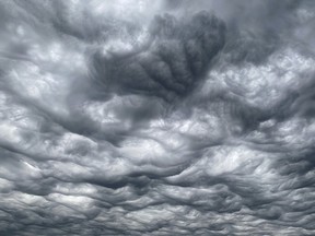
A rough sea of wavy, undulating clouds blanketed Ottawa’s skies on Sunday evening, ahead of a spectacular thunderstorm.
The clouds are known as Undulatus asperitas, an uncommon and unique cloud so named after the Latin word for roughness, said Geoff Coulson, a warning preparedness meteorologist with Environment and Climate Change Canada.
“Anyone who witnessed the sky yesterday in the Ottawa area would understand why they use that term for that cloud,” he said. “It does almost look like a rough sea, as seen from underneath, the waves and bumps.”
This type of cloud formation is rare and relatively new, Coulson said, and makes for a “bizarre, chaotic sky” that caught the eye of many in the capital region.
Do you have photos of last weekend’s asperitas clouds? Send them in to [email protected] and we’ll add some of them to our story.
What exactly are asperitas clouds?
The World Meteorological Organization officially recognized asperitas clouds in 2015, making it the first new distinct cloud type in more than 50 years.
The cloud was first proposed by the Cloud Appreciation Society in 2008, Coulson said, and the WMO studied it for years to determine it was, in fact, a distinct cloud type.
Asperitas clouds are stratocumulous clouds which are low to mid-level clouds, meaning they can be found anywhere from a few thousand metres above the ground, or three to four kilometres above the ground.
The World Meteorological Organization says asperitas clouds don’t always bring rainy weather.
However, they do often appear when rain showers and thunderstorms occur, typically in the aftermath, but sometimes beforehand, Coulson said.
In Ottawa’s case, the clouds were “all related to the weather situation,” he said, “With the passage of the cold front kicking off showers and thunderstorms, this cloud type can be associated.”
What causes asperitas clouds?
Coulson says there’s still a lot of uncertainty about why these clouds form because they are so rare.
Meteorologists theorize that the clouds are caused by “pockets” of air rising and sinking in the atmosphere, combined with winds shifting direction quickly, known as wind shear.
Yesterday, ahead of the thunderstorm, a cold front moved into the Ottawa Valley. That made the atmosphere “very unstable,” Coulson said. “We had these rising motions and sinking motions in an unsettled atmosphere.”
The result?
“We had all the ingredients for a pretty dramatic sky.”
Will it happen again?
Asperitas clouds are rare mostly because they rely on several conditions “coming together in just the right way,” Coulson says.
As for Ottawa, the forecast calls for “a much quieter weather week,” he said, with a few scattered showers and cooler, seasonal temperatures, after a mostly balmy and sunny September.
“Rare appearances aren’t in the forecast for the rest of the week.”
Is climate change the cause?
Coulson says the rare clouds are not necessarily connected to climate change.
Since meteorologists aren’t exactly sure why these clouds form, it’s difficult to say if they’ll remain rare, or be seen more often in the coming years, he said.

