If it seems like this has been an unusually dry growing season, it’s now official.
From May 1 to Aug. 8
, Ottawa received the same paltry rainfall it did in the “drought” year of 2012. In those 100 days, there was 174.5 millimetres of rain, compared to 175 millimetres for the same period 13 years ago, climatologist David Phillips said.
It may have rained in some parts of Ottawa on Thursday evening, but the moisture deficit is so serious that a three-day deluge would be needed to rectify it.
“Any rain that does fall will just run off the ground like it’s concrete,” Phillips said. “We need the kind of rain that spoils everyone’s weekend.”
There’s a slim chance that might happen. A better bet is that Ottawa will have five more days with high temperatures above 30 C starting Saturday.
That will make matters worse. Ottawa didn’t get much warm weather in April and May, with the first run of temperatures over 30 C in June. but the heat has been relentless since then, Phillips said, with 15 days above 30 C compared to a typical total of eight or nine. There were also five more days with temperatures above 29 C … and now five more hot days to come.
“I would bet it will continue warm and dry. That’s what the model says. Everyone who weighs in is saying to expect more of the same. You would need a monsoon to correct the situation. It’s almost like nature has forgotten how to rain in the Ottawa Valley,” Phillips said.
Ashley Knapton, an Almonte-area dairy farmer and agronomist, says farmers need more than a sprinkling of rain. “There’s nothing substantive in the five-day forecast.”
At this time of summer, crops of all kinds are at the “fruit full stage,” the point of a plant’s development when it directs resources to producing fruit and water needs are quite high, she said.
“The next 14 days will be really telling,” Knapton said. “I’m optimistic now. All farmers are. But we’re keeping on eye out in case it gets more severe.”
In a water management update for the Rideau Canal national historic site, Parks Canada said hot and dry conditions over an extended period had resulted in lower-than-normal local inflows and increased evaporation rates.
“Consequently, the system has transitioned from summer-like conditions to a deficit state,” it said
All three area conservation authorities in the region have raised concerns about water levels.
The Rideau Valley Conservation Authority has declared a minor low-water status for the sub-watersheds of Kemptville Creek, Jock River and the lower Rideau sub-watershed. Stream flow levels monitored within the Jock River and Kemptville Creek sub-watersheds range from 10 to 25 per cent of the normal amounts for this time of year.
However, levels in the Rideau River from Smiths Falls to Ottawa remain within navigation range, said Dylan Pfaff, an engineering technician with the conservation authority.
Under Ontario’s Low Water Response Program, which prepares provincial and municipal authorities in the event of a drought, Level 1 is an early indication of a potential drought. Level 2 is an increased likelihood of drought conditions. Levels 3 is a high likelihood of drought conditions, but does not imply an emergency.
The Carp River is at Level 2, said Kathryn Starratt, a water resources specialist with the Mississippi Valley Conservation Authority.

However, the rest of the Mississippi River catchment is considered to be within normal levels, mostly because the Mississippi has reservoirs upstream managed with dams, she said. However, even the reservoirs for the system are below average and tending toward Level 1.
‘If we don’t get rain, we’ll be pulled into a Level 3,” Starratt said. “Any rain will be completely soaked up. It will take a good storm to replenish those water levels.”
On Aug. 1, the South Nation Conservation Authority said conditions in its jurisdiction had reached the Level I threshold, and it asked users to reduce water use by 10 per cent.
The township of North Dundas has introduced outdoor water-use restrictions for all residential, commercial, institutional and industrial users in Winchester and Chesterville that are connected to the municipal water system. That means no lawn or garden watering or car washing. Hot kids? Water sprinklers and slip-and-slides are also off-limits.
Since the restrictions were introduced July 18, “groundwater levels in our drinking water sources have continued to decline. The lack of recent rainfall and limited forecasted precipitation have not allowed the aquifers — where our drinking water is sourced from — to adequately recharge,” North Dundas said in a message to its residents.
Meanwhile, farmers say how much the dry conditions affect crops depends on the crop, the soil and the location.
“You can see the crops are stressed. The leaves will curl up to conserve water,” said Duncan Ferguson, a wheat grower and grain elevator operator near Williamstown, northeast of Cornwall, where there has been no substantial rain since July 1.
Spring wheat, which is harvested in the fall, will suffer a bit, Ferguson predicted. “We’re looking at a 25 per cent reduction in the spring crop.”
Winter wheat, on the other hand, which is planted in the fall and was harvested about a week ago, produced a good crop, he said.
In 2012, dry conditions were North America-wide, Ferguson said. “This year, it’s very, very localized. Central Ontario is hurting more.”

Mel Foster, who operates Foster Family Farm near North Gower with his wife and parents, said strawberries were smaller this year, and some were sunburnt.
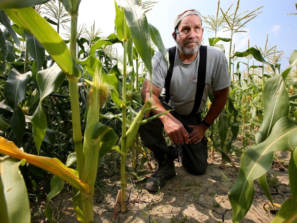
Other crops are starting to show some stress, too. The yield of green and yellow beans is lower then usual, Foster said. Corn pollinates through the transfer of pollen from the tassel to the silks and this may be affected by dry weather. It means some kernels may not develop.
But crops that put down roots in the spring, when moisture available was available, are still doing well, Foster said. Early and mid-season sweet corn, for example, is doing fine. So are beets and onions, which also established early in the season, and potatoes, which have been hilled. The farm uses a drip irrigation system, which is a very efficient user of water, delivering water to the plant’s root zone, Foster said.
The dry summer of 2012 was “the gold standard” of a drought in Ottawa, Phillips said. In one way, it was even worse than this year because 184 millimetres of precipitation fell between Jan. 1 and May 1 compared to 265 millimetres in the same time period this year.
Looking ahead, Phillips predicts a long, slow slide into winter, although hurricane season is gearing up.
One of the things that rescued Ottawa in 2012 were the rains that accompanied Hurricane Sandy as the “superstorm” rampaged into eastern Canada. Total precipitation between August and December 2012 was 421 millimetres, or slightly more than normal for that time period.
Phillips also predicts trees will put on less of a colour show this fall.
“Tress are stressed. Any rain that does fall just runs off,” he said. “The colour change will be disappointing. The leaves will fall before they get to the peak of colour.”
Our website is your destination for up-to-the-minute news, so make sure to bookmark our homepage and sign up for our newsletters so we can keep you informed.