Toronto is heading into a colder‑than‑normal stretch to start the week, with flurries, gusty winds and below‑seasonal temperatures expected before a brief warm-up arrives later in the week.
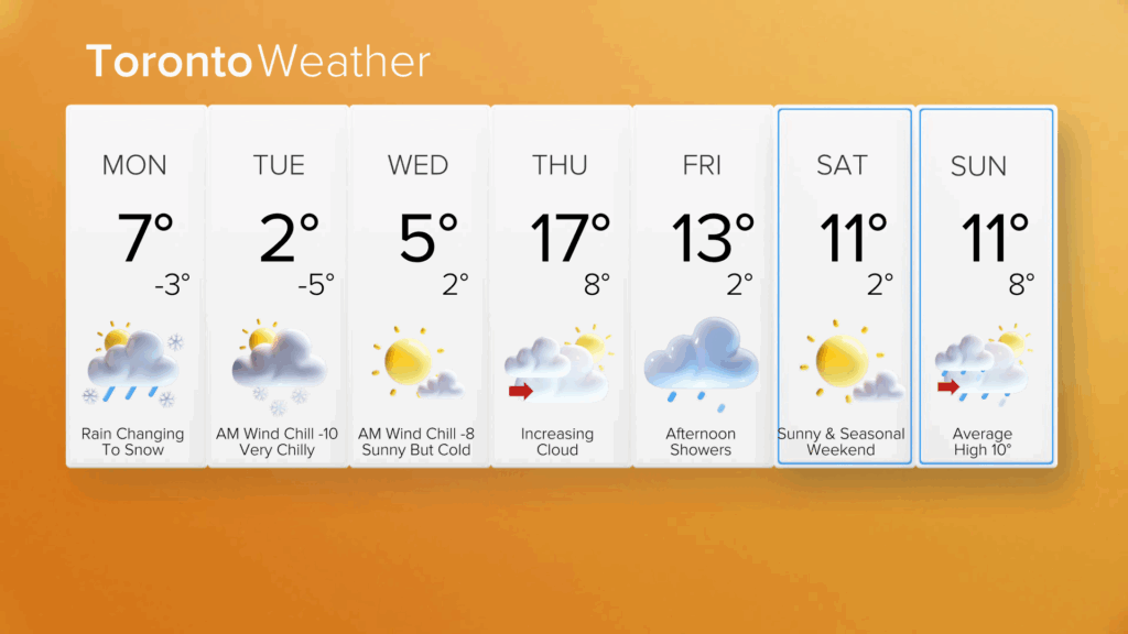
After a partly sunny Monday with scattered showers and a high topping out near 6 C, conditions will turn noticeably colder overnight and into Tuesday. Monday’s showers will turn to wet snow by late evening, and lake effect snow will continue north and east of downtown into early Tuesday morning.
A trace to 1 cm of accumulation is forecast for Toronto, but 2-4 cm could fall in areas north and east of the city, including Barrie and northern York Region.
By Monday night, temperatures fall to -3 C, and northwest winds strengthen to 30-50 km/h, making it feel even colder.
Tuesday will be the coldest day of the week. Any lingering morning flurries are expected to diminish, giving way to sunshine by the afternoon. But the cold air will be firmly in place, with a high of 2 C and a low of -5 C.
With the wind, Tuesday morning’s wind chill will be closer to -8 to -10. For context, Toronto’s normal high for this time of year is 9 C, and the normal low is -1 C.
By Wednesday, calmer and sunnier conditions return, with a forecasted high still a tad below the seasonal average of 5 C in Toronto.

Late‑week warmup with rain
A stronger warm front arrives Thursday, pushing temperatures back into double-digit territory.
Thursday will bring a mix of sun and clouds, with a high of 17 C and a chance of overnight showers. Friday’s forecast is cloudy with afternoon showers, a high of 13 C and a low of 2 C.
The late‑week bump will bring temperatures back into the mid-to-high teens before cooling back to seasonal heading into the weekend.
Click here to sign up for the CityNews Weather Guarantee and to check out Toronto’s extended forecast.