
Toronto has one of the most iconic skylines in the world with scenic views and Instagram worthy spots spread across the entire city.
The city’s most photographed and photographable locations include serene sunset scenes, street art and lake views. Peruse this list to find the perfect place for your next profile picture.
Nothing says you were there like a photo in front of the city’s name sign, and Toronto’s is located right outside City Hall, as the centrepiece of Nathan Phillips Square.
The illuminated three-dimensional sign is 10 feet tall and is flanked by a medicine wheel at one end and a maple leaf at the other. The vinyl wrap is an artwork called “Rekindle” and was designed by renowned Indigenous artist Joseph Sagaj. It highlights Indigenous culture in recognition of UNESCO’s International Decade of Indigenous Languages (2022 to 2032).
Access is free and along with the sign, Toronto’s well recognized, futuristic City Hall building is also photo-worthy and has been featured in films and television shows numerous times.
Stroll up one of the elevated walkways around the square to get a better angle of the whole sign along with City Hall in the background – two Toronto icons in one shot!
How to get there by transit: Nathan Phillips Square is located at 100 Queen Street West. You can take the 501 Queen streetcar and jump off at the University Avenue (Osgoode Station) stop, then walk east towards the square – it will be on your left. Alternately, you can take Line 1 (yellow line) of the subway to the Queen Street stop. Exit at Yonge street and walk a short distance west.
Polson Pier

Polson Pier is an entertainment complex in the city’s Port Lands area and includes a night club, pool bar and sports complex.
The area is most well known for it’s boardwalk that offers an unobstructed view of the downtown Toronto skyline and is popular for golden hour and sunset photo shoots. While the venues in the areas have their own events and pricing, access to the boardwalk area is free.
Visit at golden hour and stay for the sunset views to capture the glowing city skyline.
How to get there by transit: Polson Pier is located at 11 Polson Street and is easily accessible by bus from downtown Toronto. Take the 509 streetcar to the Ferry Docks station. From there exit on Bay Street at Harbour Street and take the 202 or 114 bus going east. The 114 bus will drop you off at Commissioners Street from where it’s a quick walk across the Cherry Street Bridge to Polson Street and down to the pier. The 202 will drop you off at Polson Street from where you can walk to the pier.
Graffiti Alley

Toronto’s famed Graffiti Alley is a one kilometre stretch of alleys sandwiched between Queen Street and Richmond Street, running from Spadina Avenue to Bathurst Street.
It’s a free, opwn air art gallery with massive murals covering the back walls of businesses with storefronts on Queen Street West and the backs of homes and garage doors that face Richmond Street. While several artworks have been up and untouched for years, many of the walls change periodically as a variety of aerosol artists leave their own unique marks on the outdoor canvasses.
The alleys are well known as backdrops for local TV shows as well as popular with residents and tourists alike for photo and music video shoots.
The walls are also sometimes used to reflect current events and socio-political shifts, with the most notable recent transformation being a show of solidarity with the Black Lives Matter movement in 2020.
Take a stroll through the area to get a taste of Toronto’s vibrant street art culture and capture some impressive, often fleeting works of aerosol art.
How to get there by transit: Take the 501 Queen streetcar and start at either end of the alleys by hopping off at Spadina Avenue or Bathurst Street and heading south toward Richmond Street. There are multiple entry points into the alleys along the way including McDougall Lane, Augusta Avenue and Portland Street.

Photo by Lianhao Qu on Unsplash
Riverdale Park East is a well loved picnic spot in the summer and tobogganing in the winter that offers beautiful views of the Toronto skyline. It is especially popular for its sunset views above a lush tree line from grassy slopes.
The park has a baseball diamond, off-leash dog area, pickle ball court and a playground among other facilities.
It’s also one of 55 parks in the city where alcoholic beverages are allowed, making it a good spot to slow down, crack a beer or bottle of wine and watch the sunset on a warm Toronto summer’s eve.
How to get there by transit: Riverdale Park East is near near Danforth and Broadview Avenues. Take the Line 2 (green line) subway to Broadview station and exit via Broadview Avenue. Walk south down Broadview until you get to the park around Montcrest Boulevard.
Chester Hill lookout
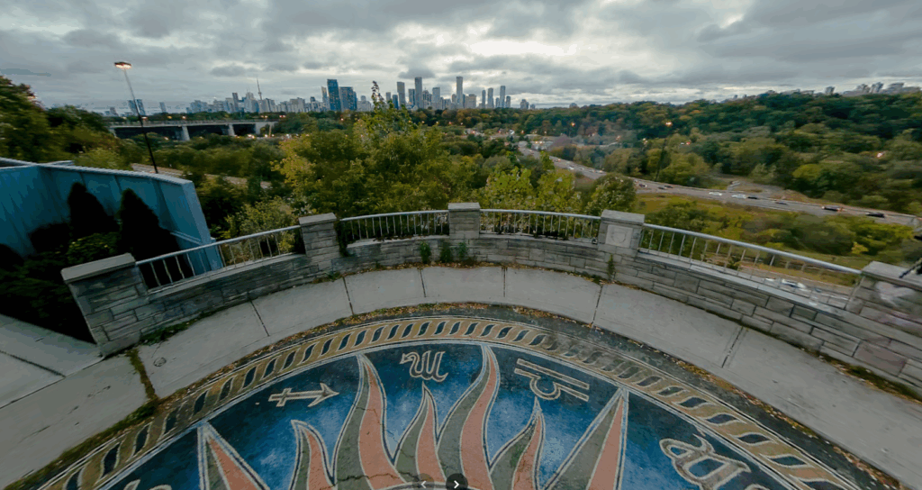
The Chester Hill lookout is hidden away in a residential area in the Rosedale neighbourhood of Toronto.
It looks over the lush Don Valley and offers sweeping views of the skyline. It’s also another popular spot for sunset views and photo opportunities.
The semi-circular lookout features a large pavement mural of an astrology wheel bearing the 12 zodiac signs by local Toronto street artist Victor Fraser – making it stand out and easy to find.
How to get there by transit: Take the Line 2 (green line) subway to Broadview station and exit via Broadview Avenue. Walk north along Broadview and turn onto Chester Hill Road and continue down to the end of the road.
Humber Bay Park West

Humber Bay Park West, as the name suggests, is in the west end of the city.
It’s a narrow area that juts out into Lake Ontario and the view of Toronto and its skyline from the park’s shores are unmatched.
Along with offering numerous photo opportunities by the water, the park is popular with bird watchers and hikers. It also has a bike trail and off-leash dog park and a pebbled beach runs through the entire area.
The shores of the park are popular for peaceful water gazing, taking in a sunrise or sunset and impressive photo opportunities of the lake with Toronto in the background.
How to get there by transit: Take the Line 2 subway (green line) to Old Mill station and transfer to the 66 bus to Lake Shore and hop off at Park Lawn Road at Lake Shore Boulevard West. Walk west along Lake Shore until you reach the park entrance. Alternately, you can take the 501 Queen Streetcar to the end of the line and jump off at Humber Loop. Transfer to the 507 Long Branch streetcar, hop off at Legion Road and walk south to the park.
Add CityNews Toronto as a trusted source on Google to see more local stories from us.
![]()

